Mile-1 App
Our popular Mile-1 app provides you with the most comprehensive highway mile marker locator service ever built. Easy to use day or night, quickly know your real-time mile marker location. Nearly every highway on the U.S. Interstate system is included along with a growing list of state highways, U.S. highways, and Canada Provincial routes. There are river and rail miles too! Use Mile-1 to help emergency personnel or roadside assistance locate you faster. The core Mile-1 location feature is free for everyone.
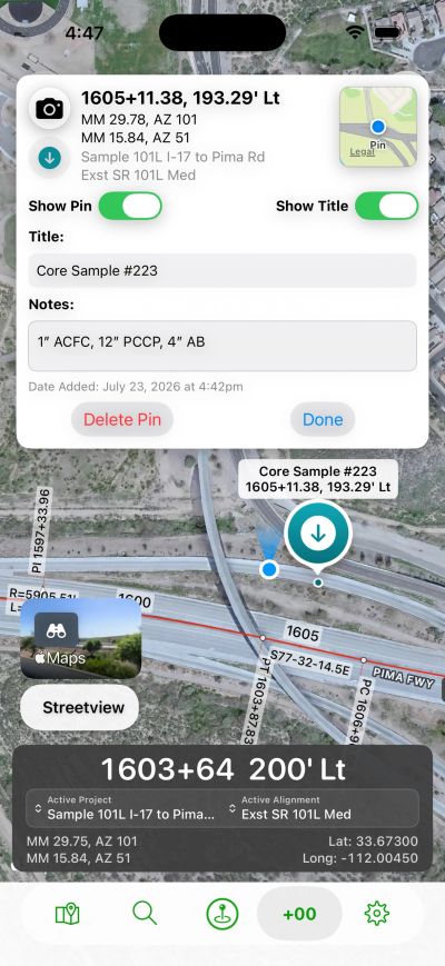
Save and share custom mile marker points or make maps with Mile-1 Pro. Combine mile markers and construction project stationing with Mile-1 Pro+ and eliminate the hassle and labor cost of determining the right locations for your field reports, testing, and documentation..
Mile-1 is available on iOS, Android, and CarPlay.


Mile-1 Pro+ (Now in Beta release)
For the Pro's, real-time active stationing is here alongside real-time mile markers!
Built for DOT, construction teams, inspection, operations, and maintenance, use the Project Manager tab to upload your OpenRoads or Civil3D LandXML alignment files to get real-time stationing in addition to real-time mile markers nationwide. Most coordinate systems in North America are supported along with custom grid adjustment factor capabilities. Upload your base files as a KML to complete the digital delivery of your project available in your pocket. These high quality tools, built by a professional engineer, are constructed with precision to handle any form of road or rail alignment including curves, spirals, and station equations for all LandXML formats.
- Add project pins, auto-tag photos with both stations and mile markers, document your field tests and issues, and share reports with your clients.
- Export your documentation in a PDF report, share pins, and share projects are all supported.
- One person can set up and validate a project within minutes and share with your team for easy import.
- Save time, improve your documentation, and gain efficiency during construction or evaluating future project alignments during site visits.
- Changes or additions to your project can easily be swapped out or updated.